- Location
- Washington
- Current protection
- Sun Lakes–Dry Falls State Park, Palouse Falls State Park, Steamboat Rock State Park
- Status
- No active campaign
- In the book
- Featured in Undiscovered America
Why should it be a National Park?
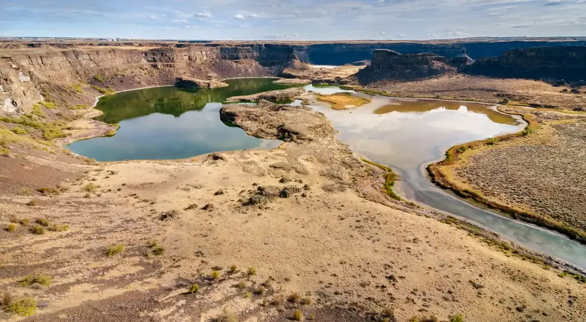
The Cascade Mountains in Washington split the state into two wildly different climate zones. In the western part of the state are thick, mossy forests and snow-capped mountains, where you can find all three of Washington's National Parks. However, east of the Cascade Mountains is a land that many people do not know about. Eastern Washington is dominated by a massive, semi-desert environment of grassland and rock formations called the Channeled Scablands.
The scablands derive their name from their dark brown appearance and how they were formed. Around 15,000-years-ago at the end of the last ice age, an enormous glacial dam held back a body of water known as Lake Missoula (roughly half the volume of present-day Lake Michigan). When the ice dam broke that water was released, carving a 660 feet deep, 60 mile-long gash known as Grand Coulee Canyon into solid basalt (one of the hardest forms of rock). Basalt boulders are now scattered across Washington and even parts of Oregon.
Dry Falls, the site of the former waterfall, is a horseshoe-shaped cliff that is twice as high and three times as wide as Niagara Falls, making it the largest confirmed waterfall in history. Today, the site of the waterfall is preserved as Sun Lakes-Dry Falls State Park. This park only protects 4,027 acres of the Scablands, while the overall region takes up more than 9.6 million-acres.
Over the last hundred years, humans began to move into the Scablands, and even into the Grand Coulee Canyon itself. A few small towns and RV parks have been established along the waters. Wherever there is beauty and waterfront, however stark, people will try to make it their own. In the Scablands we have a young, mostly undisturbed natural wonder that could redefine the Pacific Northwest as a land of contrast rather than the gloomy, rain-soaked forest that pervades culture.
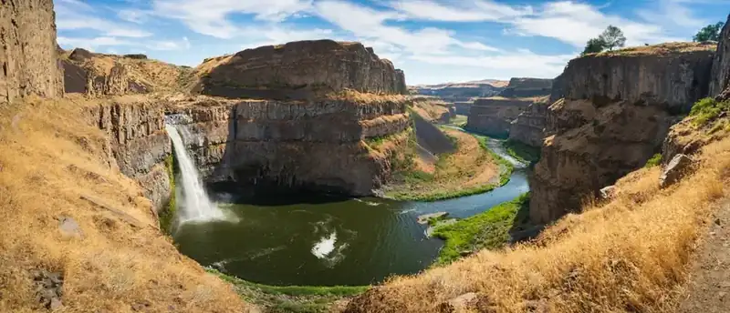
One of the most prominent features in the Scablands is Palouse Falls. Within Palouse Falls State Park, this 198 feet waterfall is a prime example of the force of the Missoula Floods. The floods dug out this canyon and diverted the Palouse River from its historic route. The full length of the Palouse River flows 167 miles, but the waterfall and canyon make up only the last four-miles before meeting with the Snake River as a tributary. The Snake and Columbia Rivers also display significant geological signs of the Missoula Floods, leaving every natural feature in southeastern Washington shaped by the event.
The Scablands environment remains largely in danger of being altered or lost. Dozens of other worthy sites like Ginkgo Petrified Forest, Saddle Mountain, Moses Coulee, Wallula Gap, and Hat Rock deserve to be better protected for research and to preserve the legacy of our geologic history.
The history of National Park Campaigns
Despite J Harlen Bretz's landmark 1920s flood geology, the Scablands were never seriously advanced as a National Park; the definitive 2001 NPS Study of Alternatives found the flood features nationally significant but too vast and fragmented for a traditional park, recommending a geologic trail — which Congress created in 2009.
- Distinct National Park attempts
- 0 that advanced (2001 study explicitly found a park infeasible)
- Other designation attempts
- 1 successful (2009 National Geologic Trail), preceded by the 2001 study and multiple trail bills
Sources
- NPS, Ice Age Floods Study of Alternatives and Environmental Assessment (Feb. 2001, nps.gov/iceagefloods/pdf/report.pdf), esp. sections A and N
- DOI testimony on S. 206 / H.R. 383 (doi.gov/ocl)
- S. Rept. 110-15 (govinfo)
- P.L. 111-11
- Ice Age Floods Institute (iafi.org)
- 1920s
J Harlen Bretz's cataclysmic-flood hypothesis. UNVERIFIED whether any 1920s–30s "Grand Coulee National Monument/Park" or "Dry Falls National Monument" was formally proposed.
- November 2, 1933
Dry Falls state land reserved (Sun Lakes–Dry Falls State Park).
- 1933–1942
Grand Coulee Dam construction.
- 1946
Coulee Dam National Recreation Area (later Lake Roosevelt NRA).
- 1995
Ice Age Floods Institute founded; lobbies for recognition.
- 1998
Public Law 105-391, Title III directs the special resource study.
- February 2001
An NPS-led, 70-member study team completes the two-year Ice Age Floods Study of Alternatives and Environmental Assessment (produced by Jones & Jones). Findings: floods features are nationally significant and suitable for the park system, but "the size, breadth, and multitude of ownerships throughout the study region make the area not feasible to consider for a traditional National Park, Monument or similar designation." Preferred Management Alternative 3: a National Geologic Trail managed by the NPS in partnership with public/private entities (no NPS land-acquisition or regulatory authority).
- 2000
Hanford Reach National Monument (adjacent context).
- 2005
S. 206 (109th Cong.); Subcommittee on National Parks hearing June 28, 2005 (S. Hrg. 109-101); reported with substitute (S. Rept. 109-144); passed Senate by unanimous consent Nov. 16, 2005. Companion H.R. 383. The Administration (Interior) opposed the bills, citing NPS maintenance-backlog priorities.
- 2007
S. 268 (Sens. Cantwell, Wyden, Craig, Murray); Rep. Doc Hastings carried House versions across the 107th–110th Congresses.
- March 30, 2009
Ice Age Floods National Geologic Trail designated in the Omnibus Public Land Management Act (P.L. 111-11); an auto route across Montana, Idaho, Washington, Oregon; not a unit of the National Park System, with $12 million authorized. (Sen. Cantwell; Rep. Hastings.)
No "Channeled Scablands National Park" bill or op-ed campaign was found. Palouse Falls became Washington's official state waterfall (2014).